Protestant Cemetery

The origins of the cemetery go back only to the 18th century. The Papal States forbade the burial of non-Catholic on grounds consecrated for Catholic cemeteries. Because the City throughout its entire history had provided hospitality to pilgrims, artists, scholars, and tourists from all over Europe, some of whom were non-Catholic, it needed a place for those who died here. Until then, non-Catholics were buried outside of or at the extreme edges of the City and mostly at night to avoid trouble and not to offend Catholic citizens. Originally an open space and public property, Romans used this space for cattle grazing and recreational activities. In the late 17th century, the Holy Office decreed that aristocratic, non-Catholics who died in the City could access this area for burial instead of the cemetery at the Muro Torto near the Pincian Hill, a site traditionally reserved for the burial of public sinners and prostitutes.
George Langton, a 25-year-old Oxford graduate student who died in 1738, became the first non-Catholic interred in the cemetery. The cemetery developed initially without any official sponsorship or maintenance. Only at the beginning of the 20th century did the civil government appoint a caretaker to maintain the property and manage its operations. The famous cypresses of the cemetery did not appear until late in its history. Among those buried here, over four thousand people, mostly, but not exclusively British, among whom many writers, poets, painters, sculptors, historians, archaeologists, scientists, and diplomats. The few Italians buried in the cemetery, represent people whose ideas and culture identify as non-traditional and, at least, somewhat foreign. These include, for example, Antonio Gramsci, leader of the Italian Communist Party during the Mussolini era.

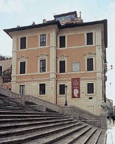
Some of the most well-known and frequently visited gravesites belong to England’s prominent Romantic 19th century poets, John Keats and Percy Bysshe Shelley. John Keats, 24 years old and seriously ill with tuberculosis, came to the City in hope of prolonging his life.

Living in a villa overlooking the Spanish Steps, he died there at the age of 25 February 24, 1821.
Keats is buried in the oldest part of the cemetery next to the grave of his friend and deathbed companion, the artist Joseph Severn who followed Keats in death many years later.
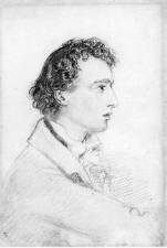
Keats had requested of Severn that his name not be carved on his gravestone. The well-known inscription reads in part: “This Grave contains all that was Mortal of the YOUNG ENGLISH POET… Here Lies One Whose Name was writ in Water Feb 24 1821”. Severn designed the tombstone with the image of a partially unstrung Greek lyre.

Joseph Severn died in 1879, aged 85, and was buried in the plot next to his friend. While Keats’ name did not appear on his own stone, Severn inscribed it on his own gravestone. Similar in design as that of Keats’, it is embossed with an artist’s palette instead of the Greek lyre on Keats’ and inscribed with the recognition that in his lifetime he was able to see his friend numbered ‘among the Immortal Poets of England’.

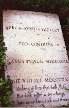
Percy Bysshe Shelley lies not far from Keats. The 29-year-old Shelley drowned in 1822 in the Gulf of Spezia during a storm that suddenly rose as he and friends sailed in a small boat. In his pocket when he died, survivors discovered a volume of Keats’s poetry. Shelley’s gravestone bears his name and the Latin phrase, “COR CORDIUM” (heart of hearts).
Cestius Pyramid
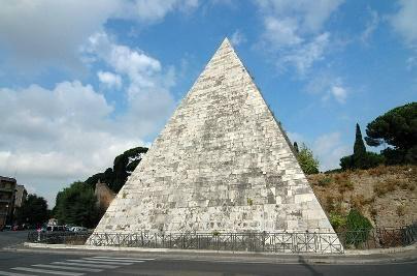
The cemetery lies adjacent to a 1st century BC tomb near the Porta San Paolo, the Caius Cestius Pyramid. The tomb, 100 feet wide and 125 feet high, consists of brick covered with marble. Cestius, a praetor and a tribune of the people, built the tomb for himself. Agrippa, close advisor and son-in-law of the emperor Augustus, served as executor of the will and oversaw the construction for his friend.
Aurelian Walls (Mura Aurelianae)
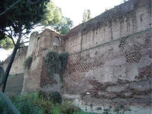
Many mistakenly believe that the Colosseum remains the largest of the City’s ancient monuments. That honor, however, goes to the Aurelian Walls, among the least visible, at least for most visitors to the City. Ancient cities defined themselves literally and metaphorically by their walls. Walls expanded with their populations. Romulus in 753 BC set a boundary (pomerium) around his ‘Roma Quadrata’; Servius Tullius, the City’s 6th king, did so again in the 6th century BC, the Servian Wall (still visible at Stazione Termini), enlarged, yet again, in the 4th; the emperor, Aurelian, expanded the stone boundary for the last time, the Aurelian Wall, in the 3rd century AD, in an effort to ward off the ever growing threat of attacks by Germanic tribes (Vandals in 270 AD).

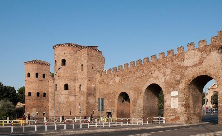
The massive walls of Aurelian, constructed within 5 years by Roman soldiers and citizens, rose twenty-six high, had a width of 10 feet and a length of twelve miles, enclosed five and a half square miles, contained almost four hundred watchtowers, encompassed the seven hills, Campo Marrzio, and Trastevere, and gave access to the City through fourteen gates. Emperor Maxentius more than doubled the height of parts of the walls within forty years of their construction. Parts of pre-existent structures were integrated into the wall itself, as, for example, the pyramid of Cestius near Porta San Paolo and the Aqua Claudia. Emperors Caligula and Claudius constructed the aqueduct in the 1st century BC. Incorporating the 3rd century aqueduct into the wall not only added to the defense of the City, but, at the same time, insured an adequate water supply in times of siege. At the height of the Imperial Age, this wall enclosed an area of five and a half square miles and contained amenities greater and more numerous than any other place in the Western world. Records (Regionary Catalogues) indicate that these included eleven fora, fifty-five temples, ten basilicas, twenty-eight libraries, eight bridges, two circuses, eight parks, two amphitheaters, three theaters, eight hundred sixty five baths, thirteen hundred fountains, five naumachia, and one hundred forty public latrines.
Until the 1980’s many of its gates functioned as points of access to the City and gateways to major thoroughfares towards all parts of Italy. Monumental and aesthetic features of parts of the walls and gates still attract the attention of artists, historians and engineers warranting the construction of a wall museum near the Porta San Sebastiano.

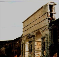
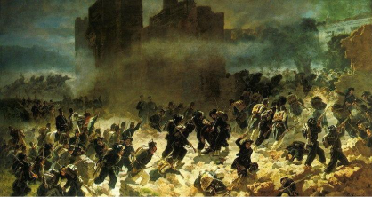
The walls long survived the 5th century fall of the City and for centuries served as its chief defense, limiting damage caused by foreign invaders such as an Arab attack in 846. On September 20, 1870, however, they were breached at the gate, Porta Pia, when the military forces (Bersaglieri) of King Victor Emmanuel II, occupied the City and established it as the capitol of the newly created Kingdom of Italy.
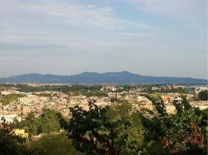
The very well-preserved walls still serve to define the boundary of the historic center, despite the ever-expanding sprawl of its suburbs towards the surrounding hill towns (Castelli Romani) in the distance.
Via Appia
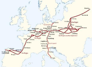
The greatest and most enduring visible monument of Roman history, despite claims made by many for the Pantheon and Colosseum, resides in its awesome and efficient system of road construction. This became the singular tool responsible for the creation, growth, and maintenance of the world’s largest imperial system. It extended more than 120,000 miles throughout Roman territories, connected them to the Imperial City, and included hundreds of bridges constructed over rivers, conduits into and out of marshlands, and tunnels cut through mountains.
Accomplished, unbelievably, without the benefits of modern earth-moving machinery or explosive devices, roads emerged slowly but surely as the product of hand tools and sheer muscle, animal (oxen, mules and horses) and human (army and slaves). Unlike the private road system of ancient Egypt, Roman roads were accessible to the public and utilized for military, commercial, and travel purposes, and included rest stops and amenities for humans and animals at regular intervals. No better road system existed in Europe until the 19th century.
The Roman Republic began a period of expansive growth in the 4th century BC as more and more of its Italian neighbors came under its dominion.
Three Samnite Wars (343-290 BC) resulted in a fourfold increase in its boundaries. Roadways played an important role in this Roman military success, providing easy maneuverability to a state at war and basic goods and services to an otherwise flourishing community. Around 312 BC the censor Appius Claudius Caecus, on his own initiative and without Senate approval, undertook two enormously important public works projects which changed the course of Roman history forever: the construction of the City’s first aqueduct and, as well, its first major road system, a 125-mile road from the City to Capua, the capitol of Campania in the south, stronghold of the Samnites, and fertile farm land. His successes resulted in securing an abundant and constant water supply and brought about the City’s first, major, paved, roadway, the Via Appia, which, thereafter, became known to Romans as the ‘queen of all the roads’ (regina viarum). In time the Romans extended the road so that it crossed the peninsula from the West to East coasts, the model for the construction of its many roads connecting Romans to the outside world inside and far beyond its own borders.

In recognition of his spectacular achievements, Appius subsequently held many other high public offices, including that of consul (2 times).
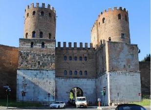
The Porta San Sebastiano, the largest and best-preserved gate in the entire wall system opens to the Via Appia. The gate was transformed into the private residence of the Secretary of the Fascist Party, Ettore Muti, from 1942-1943.
In the course of its long, uninterrupted history, the road has witnessed many important events: thousands of followers of the rebel slave Spartacus were crucified along its edges; St. Paul travelled along it to reach the City in the mid-1st century; St. Peter fled Nero’s persecution on it and encountered Jesus who asked him where he was going (‘quo vadis’); during World War II, American forces invading Italy at Anzio in 1943, followed its lines to Monte Cassino and later northward to liberate the City from Nazi occupation; in the 1960 Summer Olympics the men’s marathon ran its course on a segment of it.

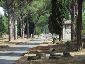
In the 1950’s the State created the modern road system encircling the City (Grande Raccordo Anulare). From it highways (autostrade) lead to all parts of the country. Some sections of the Via Appia Antica, remarkably, remain active, lined with monuments, catacombs, restaurants, and private villas.
Tourists come by bus in great numbers to visit places such as the Church of Domine Quo Vadis, Saints Callistus and Sebastian catacombs, Caecilia Metella tomb, Ardeatine Caves, and many others as well. Other sections have become part of a system of public parks allowing pedestrians to recreate and walk 10 miles along its pathway.
